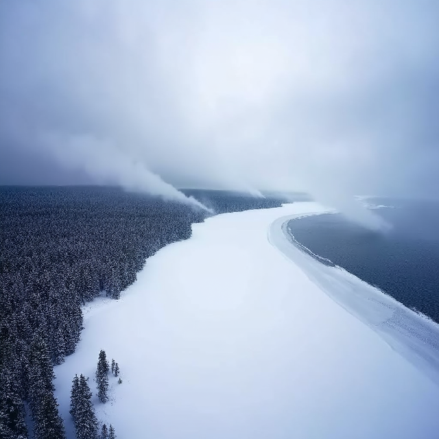
Introduction to Lake Effect Snow
Lake effect snow is a fascinating and powerful weather phenomenon that occurs when cold air passes over the warmer waters of large lakes, such as the Great Lakes in North America. This interaction leads to localized heavy snowfall, which can have significant impacts on communities, transportation, and daily life.
How Does Lake Effect Snow Form?
-
Cold Air Meets Warm Water: The process begins when a cold air mass, often originating from Canada, moves over the relatively warm waters of a large lake. The temperature contrast between the cold air and the warmer water is key to the formation of lake effect snow.
-
Evaporation and Moisture Transfer: As the cold air passes over the unfrozen lake water, it picks up moisture and heat from the water surface. This causes the lower layer of air to become warmer and more humid, which leads to the formation of clouds.
-
Cloud Formation and Precipitation: The warm, moist air rises into the colder atmosphere above, where it cools, condenses, and forms clouds. These clouds can grow into narrow bands, often referred to as “streamers,” which produce heavy snowfall on the downwind side of the lake.
-
Localized Snowfall: The snowfall is typically localized and can be extremely intense, with rates sometimes exceeding several inches per hour. This localized nature means that areas just a few miles apart can experience vastly different snowfall amounts.
Characteristics of Lake Effect Snow
- Heavy Snowfall Rates: Lake effect snowstorms can produce snowfall rates of 2 to 3 inches per hour, leading to rapid accumulation.
- Narrow Snow Bands: The snow often falls in narrow bands, which can result in significant variations in snow depth over short distances.
- Long Duration: Lake effect snow events can last for several days, especially when the cold air remains over the lake.
Impact of Lake Effect Snow
- Transportation Disruptions: The heavy and localized nature of lake effect snow can lead to road closures, flight cancellations, and other transportation disruptions.
- Economic Effects: The impact on agriculture, tourism, and other industries can be significant, especially in regions where the economy is heavily reliant on winter activities.
- Daily Life Challenges: Residents in affected areas often face challenges such as clearing snow from driveways and sidewalks, increased energy consumption for heating, and potential disruptions to daily routines.
Regions Affected by Lake Effect Snow
While the Great Lakes region in North America is most famously associated with lake effect snow, similar phenomena occur in other parts of the world. These include:
- North America: The Great Lakes, particularly areas downwind of lakes such as Lake Erie and Lake Ontario.
- Europe: Regions near large bodies of water like the Baltic Sea and the Adriatic Sea experience similar localized snowfall events.
- Asia: Areas around Lake Baikal in Russia and parts of Japan also see lake effect snow.
Conclusion
Lake effect snow is a striking example of how atmospheric conditions interact with large bodies of water to create powerful and localized weather phenomena. Understanding the formation and impact of lake effect snow is crucial for predicting weather patterns, preparing for potential disruptions, and appreciating the beauty and complexity of Earth’s climate system.
The Role of the National Weather Service (NWS): Monitoring and Warning Systems for Lake Effect Snow Events
Lake effect snow events are a common yet potentially dangerous weather phenomenon, especially around the Great Lakes region in the United States. The National Weather Service (NWS) plays a critical role in monitoring these events and issuing timely warnings to protect life and property. Here’s how the NWS uses advanced tools and parameters to predict and warn about lake effect snow storms accurately:
Monitoring Lake Effect Snow
The NWS employs a variety of tools and techniques to monitor lake effect snow events:
-
Doppler Radar: High-resolution radar systems provide detailed images of snow bands, allowing forecasters to track the location, intensity, and movement of snowfall in real time.
-
Satellite Imagery: Satellites like GOES-R Series (Geostationary Operational Environmental Satellite) offer high-resolution imagery of cloud patterns and lake surface temperatures, helping identify areas where lake effect snow is likely to develop.
-
Surface Observations: Automated Surface Observing Systems (ASOS) provide real-time data on temperature, humidity, wind speed, and snowfall rates at airports and weather stations across the Great Lakes region.
-
Lake Snow Parameter (LSP): The LSP is a tool designed specifically for lake effect snow forecasting. It uses historical data to predict the likelihood of high snowfall rates based on factors like wind direction, temperature differences between the air and lake water, and moisture content.
Parameters for Accurate Predictions
To issue accurate warnings, NWS forecasters rely on several key parameters:
-
Temperature Differences: The contrast between cold air temperatures and warmer lake water is a primary driver of lake effect snow. Larger temperature differences lead to more intense snowfall.
-
Wind Direction and Speed: Winds that blow across long stretches of open water (“fetch”) pick up moisture and energy, fueling heavy snowfall. Wind direction determines where the snow bands will form.
-
Moisture Content: High levels of atmospheric moisture over the lakes are essential for significant snow accumulation.
-
Instability in the Atmosphere: Vertical instability allows snow-bearing air to rise, cool, and condense into heavy snow showers.
-
Snowfall Rates: Radar and surface observations help forecasters estimate how quickly snow is accumulating, which is critical for issuing timely warnings.
Warning Systems
When a lake effect snow event is predicted or observed, the NWS activates its robust warning system:
-
Lake Effect Snow Warnings: Issued when heavy snowfall rates (typically exceeding 2 inches per hour) are expected to cause hazardous travel conditions and significant disruptions.
-
Winter Storm Watches/Advisories: These alerts are issued when conditions are favorable for lake effect snow, but the timing or intensity is uncertain.
-
Emergency Alerts: In extreme cases, the NWS partners with emergency management officials to issue urgent alerts through cell phones and media outlets.
-
Social Media and Public Outreach: The NWS uses platforms like Twitter and Facebook to share real-time updates, radar imagery, and safety tips during active snow events.
Why Monitoring Matters
Lake effect snow can have a significant impact on daily life, including:
- Travel Disruptions: Heavy snowfall can make roads impassable and shut down airports.
- Power Outages: Accumulating snow can weigh down power lines and cause outages.
- Economic Impacts: Snow removal, lost productivity, and damaged infrastructure cost communities millions of dollars.
By leveraging advanced monitoring tools and issuing timely warnings, the NWS helps protect lives and property while minimizing disruptions caused by lake effect snow events.
Share this post to spread awareness about how the NWS keeps us safe during winter storms!
#LakeEffectSnow #WinterWeather #NWS #StaySafe
Key Factors Influencing Lake Effect Snow Intensity
Lake effect snow can bring dramatic winter weather conditions, blanketing areas in thick layers of snow seemingly out of nowhere. But what drives this phenomenon? Let’s dive into the key factors that influence the intensity of lake effect snow.
1. Wind Direction: The Steering Wheel
Wind direction plays a pivotal role in determining where and how intensely it snows. Research from NOAA highlights that wind direction dictates the location of heavy snowfall along coastlines. For example, northwesterly winds over the Great Lakes often lead to significant snowfall in areas like Buffalo, NY, while southeasterly winds can cause intense snow bands over Lake Michigan. The interaction between wind patterns and lake geometry shapes the distribution and intensity of snowfall. Essentially, wind direction acts as Mother Nature’s steering wheel, guiding where the snow will fall.
2. Temperature Differences: The Powerhouse
Lake surface temperature (LST) and atmospheric temperature gradients are the engines behind lake effect snow. A study by Kristovich and Laird found that LST variations significantly impact the location of lake-effect clouds and snowfall intensity. When cold air passes over warmer lakes, it picks up moisture and heat, leading to convection and heavy snowfall. The greater the temperature difference, the more intense the snowfall. This is why areas downwind of large bodies of water often experience the heaviest snowfall.
3. Lower Atmosphere Stability: The Mood Setter
Atmospheric stability determines how energy is distributed in the lower atmosphere. A stable atmosphere can suppress vertical motions, leading to less intense snowfall, while an unstable atmosphere allows for vigorous convection, intensifying snowfall. Research from the National Weather Service (NWS) emphasizes that atmospheric instability enhances updrafts and downdrafts, which are critical for heavy lake effect snow events.
4. Cross-Interactions Between Wind and Temperature
The interplay between wind and temperature is a double-edged sword. Wind can redistribute heat, either enhancing or reducing snowfall depending on other conditions. For instance, strong winds can increase evaporation from the lake surface, amplifying snowfall intensity, but they can also disrupt the organization of snow bands, leading to more scattered snowfall.
5. Atmospheric Conditions: The Final Touch
Other atmospheric conditions, such as humidity, surface roughness, and local topography, also play a role in shaping snow distribution. High humidity allows for more intense snowfall, while surface roughness can enhance turbulence, affecting snow accumulation patterns. Terrain features like hills and valleys can funnel winds, leading to localized heavy snowfall.
In Summary
Lake effect snow is a complex phenomenon influenced by wind direction, temperature differences, atmospheric stability, and their interactions. These factors work together to create the perfect storm of winter weather. Understanding these dynamics helps us better predict and prepare for intense snow events. So next time you’re caught in a lake effect snowstorm, remember the intricate dance of meteorological forces at play!
#LakeEffectSnow #WinterWeather #Meteorology
Impact Analysis of Snowstorms: Understanding the Far-Reaching Consequences
Snowstorms are more than just a winter wonderland scene. They bring significant disruptions to our daily lives, economies, and infrastructure. Let’s dive into how these storms impact society and the economy, backed by real-world examples and data.
1. Travel Disruption: Grounded Flights and Frozen Roads
Snowstorms are notorious for causing travel chaos. Thousands of flights are canceled or delayed, stranding millions of travelers. For instance, a recent winter storm in the U.S. grounded over 2,000 flights, while in South Korea, a historic snowstorm caused widespread disruptions at Incheon International Airport.
Roads aren’t spared either—hundreds of village roads and major highways are closed due to heavy snowfall. Amtrak train services and public transit systems also face significant delays, leaving commuters stranded. The economic ripple effect? Billions lost in productivity and tourism revenue.
2. Economic Losses: A Heavy Toll on Industries
The financial impact of snowstorms is staggering. According to AccuWeather, damages from a single snowstorm can reach up to $155 billion. This includes:
- Agriculture: Farmers face losses as crops like winter wheat and citrus are damaged by freezing temperatures.
- Small Businesses: Local shops and restaurants see a drop in customer traffic during heavy snowfall.
- Infrastructure Costs: Repairing damaged roads, power lines, and buildings adds up quickly.
The Insurance Information Institute reports that winter storms caused nearly $6 billion in insured losses in 2022 alone.
3. Agricultural Impact: Crops and Livestock at Risk
Snowstorms can devastate agricultural sectors. Extreme cold snaps damage crops, with winter wheat production areas at significant risk when temperatures drop below freezing. In the U.S., experts warn that 30% of winter wheat production could be affected by harsh weather conditions.
Livestock also suffer, with cattle losses reaching tens of thousands during severe snowstorms. The economic impact extends beyond immediate losses, affecting long-term food security and supply chains.
4. Infrastructure Damage: Power Outages and Structural Failures
Heavy snowfall and freezing rain take a toll on infrastructure. Power grids are overwhelmed, leading to widespread outages. In Germany, for example, entire regions experienced disruptions due to heavy snowfall.
Buildings and roads aren’t immune either. Roofs collapse under the weight of snow, and repeated freeze-thaw cycles cause potholes and surface deterioration on highways. The cost of repairs? Billions of dollars annually.
5. Societal Consequences: Health Risks and Community Disruptions
Beyond economics, snowstorms pose serious health risks. Hypothermia, frostbite, and accidents from icy conditions are common. Vulnerable populations, like the elderly and homeless, are disproportionately affected.
Schools and businesses close, disrupting daily routines and placing additional burdens on families. Mental health also takes a hit as isolation and stress increase during prolonged winter storms.
The Bigger Picture
Snowstorms remind us of nature’s power and our vulnerability. While we can’t control the weather, preparedness is key. From strengthening infrastructure to supporting affected communities, we must act to mitigate these impacts.
The next time a snowstorm hits, remember—it’s not just about shoveling snow; it’s about protecting lives, livelihoods, and our shared future.
#Snowstorms #WinterWeather #ClimateImpact #EconomicDisruption
Case Studies of Notable Lake Effect Snow Events
Lake effect snowstorms are fascinating meteorological phenomena that can have significant impacts on local communities, ecosystems, and economies. These events occur when cold air passes over warmer lake waters, leading to localized heavy snowfall. Below, we explore some notable case studies of lake effect snow events, their characteristics, impacts, and lessons learned.
1. The 2014 Buffalo Lake Effect Snowstorm
- What Happened: In November 2014, a powerful lake effect snowstorm hit Buffalo, New York, dumping over 7 feet of snow in just five days. The storm was caused by cold Arctic air moving over the relatively warm waters of Lake Erie and Lake Ontario.
- Key Characteristics:
- Snowfall rates reached up to 3 inches per hour.
- Narrow bands of intense snowfall caused extreme localized impacts, with some areas receiving over 6 feet of snow while nearby locations saw little to no accumulation.
- The storm stranded hundreds of vehicles on roads and forced the closure of major highways.
- Impacts:
- Economic disruption: Businesses were forced to close, and supply chains were interrupted.
- Public safety: Emergency services were overwhelmed, and thousands of residents were left without power or heat.
- Lessons Learned: The storm highlighted the importance of accurate forecasting and timely communication. It also underscored the need for better preparedness measures, such as stockpiling snow removal equipment and improving emergency response plans.
2. The 2020 Lake Effect Snow Event in the Great Lakes Region
- What Happened: In February 2020, a prolonged lake effect snow event affected multiple areas around the Great Lakes, including parts of Michigan, Ohio, Pennsylvania, and New York. The storm was fueled by record-warm lake surface temperatures and persistent cold air.
- Key Characteristics:
- Snowfall totals exceeded 6 feet in some areas, with drifts reaching as high as 15 feet.
- The storm persisted for over a week, causing prolonged disruptions to daily life.
- Wind speeds of up to 50 mph led to severe blowing snow and reduced visibility.
- Impacts:
- Transportation: Thousands of flights were canceled or rerouted, and major highways were shut down due to hazardous conditions.
- Agriculture: Livestock faced extreme cold stress, and snow-covered fields disrupted winter farming activities.
- Lessons Learned: This event emphasized the role of climate change in exacerbating lake effect snowstorms. Warmer lake temperatures and reduced ice cover can amplify snowfall totals, making such events more frequent and intense in the future.
3. The 2019 Lake Effect Snowbands Over Lake Superior
- What Happened: In January 2019, a series of lake effect snowbands developed over Lake Superior, impacting regions in Minnesota, Wisconsin, and Michigan. The storm was characterized by narrow but intense bands of snowfall.
- Key Characteristics:
- Snowfall rates reached up to 2 inches per hour in localized areas.
- The snowbands were highly mobile, shifting their position multiple times during the event.
- The storm caused significant disruptions to maritime traffic on Lake Superior.
- Impacts:
- Environmental: Heavy snowfall disrupted local wildlife habitats and affected water quality in nearby streams and rivers.
- Economic: Snow removal costs soared for municipalities, straining local budgets.
- Lessons Learned: This event highlighted the importance of real-time monitoring and adaptive management strategies to mitigate the effects of lake effect snowstorms.
Broader Impacts of Lake Effect Snow Events
Lake effect snowstorms have far-reaching consequences beyond immediate disruptions. They can:
- Affect Ecosystems: Heavy snowfall can alter local ecosystems, impacting plant growth and wildlife habitats.
- Influence Climate Patterns: Lake effect snow plays a role in regional climate variability and can even influence larger-scale weather patterns.
- Shape Human Settlements: Communities in lake effect snow-prone areas must adapt their infrastructure, transportation systems, and emergency response plans to cope with these events.
Lessons Learned from Lake Effect Snow
The study of notable lake effect snow events provides valuable insights for future preparedness:
- Improved Forecasting: Advances in radar technology and atmospheric modeling have enhanced our ability to predict lake effect snowstorms.
- Community Preparedness: Education campaigns, emergency stockpiles, and robust infrastructure are critical for mitigating the impacts of these events.
- Climate Resilience: Understanding how climate change influences lake effect snow can help communities adapt to future challenges.
Lake effect snowstorms remind us of the awe-inspiring power of nature and the importance of being prepared for extreme weather events. By studying past events, we can build a more resilient future for communities affected by these phenomena.
#LakeEffectSnow #WinterWeather #ClimateResilience #GreatLakes
Conclusion and Future Directions
Lake effect snow remains a fascinating yet complex weather phenomenon that significantly impacts communities around the world, particularly in regions like the Great Lakes. This article has explored various aspects of lake effect snow, from its formation mechanisms to its societal implications. As we move forward, it is crucial to focus on enhancing our ability to predict, prepare for, and respond to these events effectively.
Key Takeaways
- Improving Warning Systems: Advances in technology, such as the Lake Snow Parameter (LSP) and machine learning models, have shown promise in increasing the accuracy of lake effect snow forecasts. These tools help meteorologists better anticipate the location, timing, and intensity of snowfall bands.
- Public Preparedness: Community education programs are vital for ensuring residents understand the risks associated with lake effect snow. By fostering a culture of preparedness, communities can mitigate the impacts of heavy snowfall, such as stockpiling supplies, creating emergency plans, and staying informed through reliable sources.
- Scientific Research: Continued research into the dynamics of lake effect snow, including ice microphysics and atmospheric interactions, is essential for improving predictive models. Integrating advanced technologies like satellite-derived data and artificial intelligence can further enhance our understanding and forecasting capabilities.
Future Directions
To build a more resilient future, the following strategies should be prioritized:
- Enhancing Early Warning Systems: Strengthening early warning systems through better data integration and real-time monitoring will enable faster and more accurate alerts, saving lives and reducing disruptions.
- Expanding Public Education: Developing accessible educational materials and conducting regular drills can ensure that communities are well-prepared for extreme weather events.
- Advancing Scientific Collaboration: Encouraging interdisciplinary research and international collaboration will accelerate the development of more sophisticated models and tools for predicting and managing lake effect snow.
By combining cutting-edge technology, robust public education, and collaborative scientific efforts, we can reduce the risks posed by lake effect snow and create safer, more resilient communities. The future holds immense potential for innovation in this field, and it is up to us to seize these opportunities and build a better tomorrow.
#LakeEffectSnow #WeatherInnovation #CommunityResilience
The question is asking about the article’s explanation of how climate change impacts lake-effect snow beyond rising temperatures, specifically regarding wind shifts and ice coverage.
The article briefly discusses warmer lake temperatures intensifying snowfall but doesn’t fully explore wind shifts and reduced ice coverage. Clarifying whether these changes are directly caused by climate change or natural variations worsened by it would enhance understanding.
I’m interested in how the article connects changes in wind patterns and reduced lake ice to broader climate change trends rather than natural variability, as these factors affect lake-effect snow dynamics.
The article shows that warmer lake temperatures can boost snowfall, linking temperature rises to stronger lake-effect snow events. However, it doesn’t clarify if these changes are due to climate change or natural variability. To better explain this connection, the article could investigate whether rising temperatures stem from long-term climate change rather than short-term weather patterns.
I’m curious if the article explains whether changes in lake temperatures causing heavier snowfalls are due to climate change or natural variations.